

Key messages
- Heat plans help governments and organisations support members of the community who are most at risk during extreme heat and heatwaves.
- The department has published resources to help planning for heat and the development and review of heat plans
Extreme heat and heatwaves can affect health by worsening medical conditions or causing potentially fatal health problems, like heatstroke. Extreme heat and heatwaves also affect Victoria's natural, built and economic environments, often through the compromised operation of critical infrastructure, facilities and services. As such, good preparation and changes to organisational processes may be required to reduce the risk to public health during extreme heat and heatwaves.
Heat health planning guide for health and community services
The Heat health preparedness guidance for health and community services has been written with and for health and community services to provide considerations for their preparedness during extreme heat and heatwaves. This document contains practical suggestions for what organisations can do to minimise the effect of extreme heat and heatwaves on staff, patients and clients, the facilities and the services provided.
The document also explains the department's heat warning system and the Bureau of Meteorology's national heatwave warning service.
Heatwave planning guide for local councils
The Heatwave planning guide: development of heatwave plans in local councils in Victoria assists local governments to address extreme heat and heatwaves at the community level.
The guide provides local governments with:
- information about extreme heat and heatwaves and municipal planning
- guidance on how to develop a heat plan
- examples of stakeholders and partners to consider in the planning process
- actions recommended for councils to incorporate in their heat plan
- advice on developing a communication strategy.
Heatwave plan review tool
The Heatwave plan review tool provides guidance for organisations as they review their heatwave plans. The review tool provides:
- information about the context of reviewing heat plans
- suggested information to include in a heat plan
- templates to capture data and feedback during the review process
- ideas for facilitating discussion with clients, staff and stakeholders.
Heatwave planning guide for residential aged care services
The Residential aged care services heatwave ready resource has been developed to support residential aged care service providers develop their heat plans. It includes:
- a specific checklist that can be used to assist with preparations for extreme heat.
- heat health information for staff, residents and their families.
Historic heat health alerts - December 2010 to March 2022
Between 1 December 2010 and 1 March 2022, the Department of Health (the department) operated the Heat Health Alert system each year through monitoring forecast temperatures around the state by weather forecast district and issuing Heat Health Alerts.
This public early warning system was developed to notify councils, departmental program areas, hospitals, and health and community service providers of forecast heatwave conditions which were likely to impact health. The forecasts were actively monitored from 1 December to 1 March and extended as required.
The system operated under an informal pilot program in the summer seasons of 2008/09 and 2009/10 and underwent continual improvements as it was expanded across the state. This dataset therefore captures the Heat Health Alerts issued under the formal system that commenced in the summer season of 2010/11 to the 2021/22 summer season.
Due to the alignment of the department’s system to the Bureau of Meteorology’s National Heatwave Service from the 2022-23 summer onwards, the dataset linked below provides Heat Health Alert data up to March 2022. Heat Health Alerts and Heatwave Warnings use different triggers so the data from each of the two systems are not comparable.
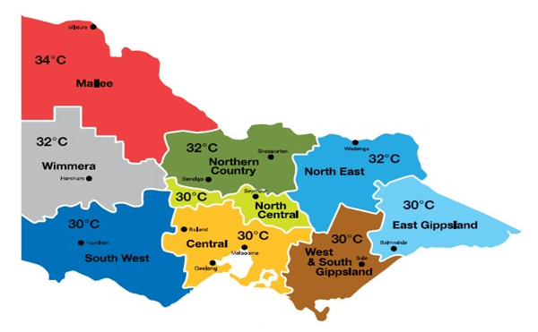
The department’s system used heat health temperature thresholds which are the lower temperature limits above which heat-related illness and mortality increases substantially. These thresholds differed by weather forecast district to recognise the higher temperatures experienced in northern parts of Victoria and lower temperatures experienced by southern areas of the state (Figure 1).
Weather forecast districts and corresponding heat health temperature thresholds

Calculating the average temperature
During the system’s operational period, the department monitored the Bureau of Meteorology’s (the Bureau) forecast daily minimum and maximum temperatures and calculated the daily average temperature for each weather forecast district. The average temperature for any given day is the average of the forecast daily maximum temperature and the forecast overnight temperature (which is the daily minimum for the following day).
An example of this calculation is demonstrated below.
The average temperature is calculated from the forecast daily maximum (in this case Tuesday) and the forecast overnight temperature, which is the daily minimum for the following day (in this case Wednesday).
| Day and temperature | Average calculation |
|---|---|
Tuesday Min: 20°C Wednesday Min: 25°C | Calculation for Tuesday: (38 +25)/2 = 31.5°C Note: The threshold for Melbourne = average of 30°C The temperature forecast indicates that the threshold will be exceeded. |
This calculation was repeated for each of the 7 days included in the daily forecast.
The department issued a Heat Health Alert when the Bureau’s 7-day forecast reached or exceeded the pre-determined heat health temperature thresholds for a specific weather forecast district. The Heat Health Alert provided an early notification to subscribers of forecast extreme heat and heatwaves.
Victorian Department of Health – Heat Health Alerts (1 December 2010 – 1 March 2022) dataset
This dataset includes all Heat Health Alerts by the Chief Health Officer in Victoria from 1 December 2010 to 1 March 2022 (inclusive). Descriptions of the variables contained within this dataset are described in the dataset page provided below.
Summary statistics (1 December 2010 - 1 March 2022)
This map provides a summary of Victoria's historic heat health alerts. Click on individual weather forecast districts to access summary statistics for that district.
Health impacts of extreme heat
This report describes heat-related emergency department (ED) presentations and hospital admissions in Victoria between 1 November 2010 and 31 March 2022 on the day of and the day after a heat health alert was issued.
Expand the dashboard for a better view
More information on this report
Updated